Ever since India, China border conflict broke out almost two years ago, the Chinese side has carried out massive infrastructure development on a war footing.
As if that were not enough, it has also been invested in constructing settlements in the eastern sector of the Line of Actual Control (LAC) near Arunachal Pradesh. India too has ramped up its border infrastructure like never before in the past few years.
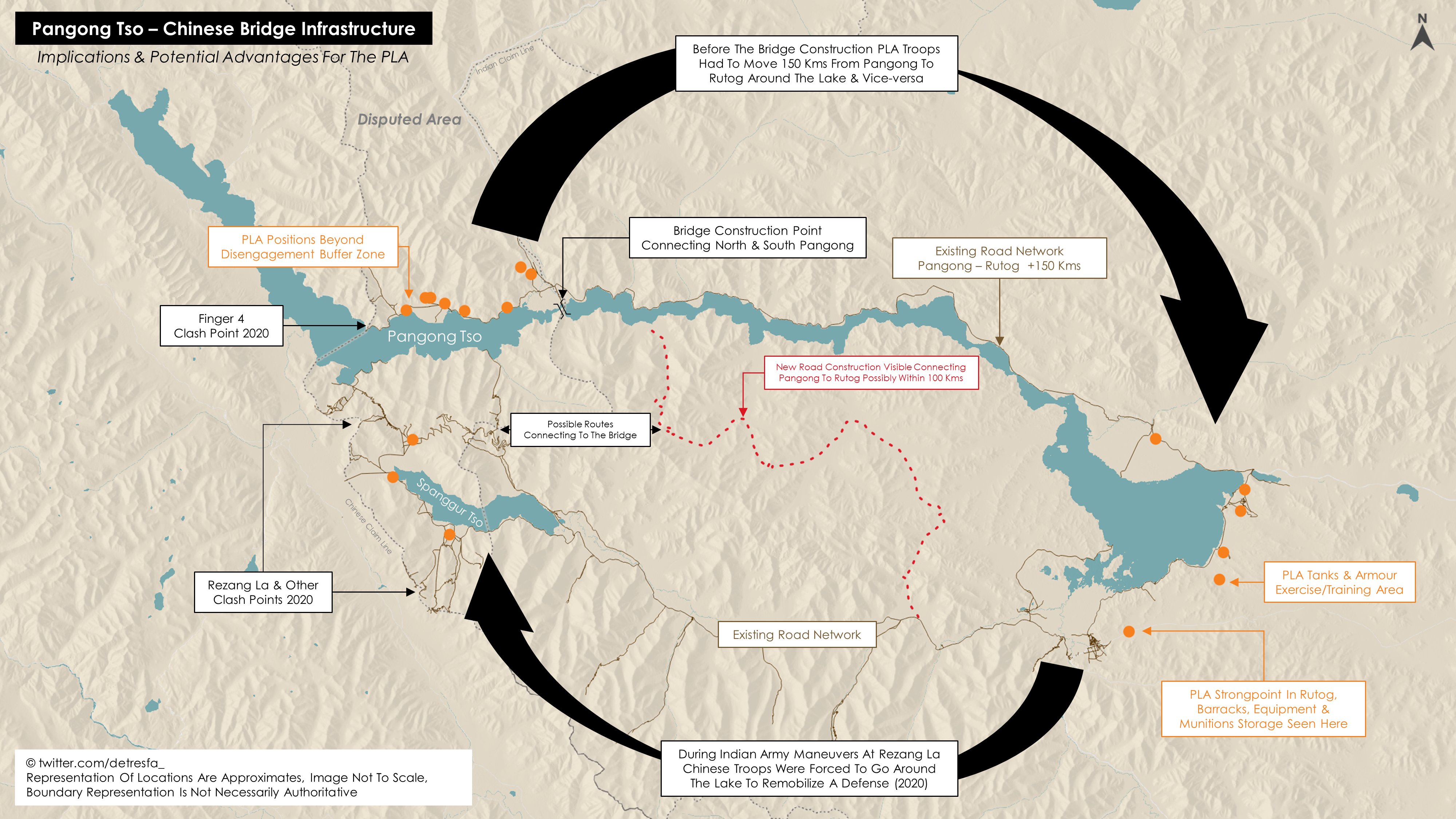
Now, the Chinese side is apparently constructing a bridge over the Pangong Tso Lake, as reported by The Print earlier this month. The bridge would cut a 180-kilometer loop from Khurnak at the north bank to the south bank of the lake through Rudok.
It’s pertinent to note that the 14th round of military commander-level talks between India and China remained inconclusive last week, indicating the ongoing border impasse is here to stay, at least for now.
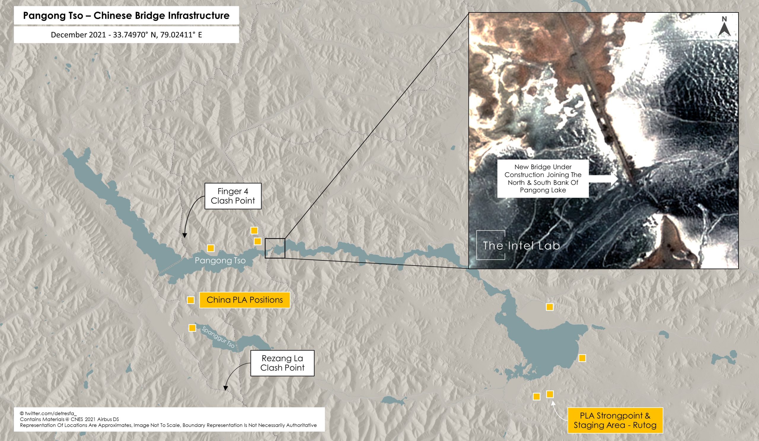
The 8-meter-wide bridge is located immediately south of a Chinese army field base on the North Bank of the Pangong Tso, where Chinese field hospitals and soldier accommodations were visible during the 2020 standoff.
NDTV analyzed satellite images from January 16 and said that Chinese construction workers are using a big crane to help attach the bridge’s pillars with concrete slabs on which the tarmac will be laid.
Given the scope of the project, the bridge might be finished in a matter of months; however, road access to Rutog, China’s largest military base in the region, will take longer than that. The completion of the bridge, which is visible for the first time in high-resolution satellite images, would allow the Chinese forces to easily mobilize soldiers on either side of the Lake.
India’s External Affairs Ministry, which has been monitoring the Chinese construction activity, says, ”This bridge is being constructed in areas that have been under illegal occupation by China for around 60 years now. As you are well aware India has never accepted such illegal occupation.”
The spokesperson of the Ministry also rubbished rumors about PLA troops hosting a Chinese flag at Galwan, which saw the bloody conflict leading to the death of 20 Indian troops and four PLA soldiers.
China’s Bid To Change Status Quo?
It is believed the bridge is being built more than 20 kilometers east of Finger 8 on the lake’s north side. India views Finger 8 as a part of the LAC. The bridge is located in Rutog County, close east of Khurnak Fort, where the PLA has frontier bases.
At Khurnak Fort, there is a frontier defense company, while further east at Banmozhang, there is a water squadron, The Indian Express reported.
This could be interpreted as a Chinese attempt at fortifying and occupying all the ends of the region that could give it a strategic advantage over its opponent.
Khurnak Fort, which was once part of India, has been under Chinese rule since 1958. The LAC or the disputed border lies a long way west from Khurnak Fort, with India claiming it at Finger 8 and China claiming it at Finger 4. After the standoff began, various friction points arose, including the north and south banks of the lake.
The bridge is being built with prefabricated structures to counter any future Indian Army operation similar to the one that took place in August 2020, which resulted in the capture of commanding heights on the Pangong Tso’s southern banks, The Print had earlier reported.
Towards the end of August 2020, the Indian Army had captured the heights along the southern bank of the lake overlooking the Finger 4 area that the Chinese had occupied. This gave major bargaining power to the Indian side and aided it in the disengagement process.
Incase you're still wondering why the new bridge at #PangongTso matters, here's an explainer on its implications & potential advantages it holds for #China's troops in the area, very likely a lesson learnt from #India's maneuvers at Rezang La in 2020 https://t.co/wsQwQuHQT9 pic.twitter.com/xoAzkWIhqY
— Damien Symon (@detresfa_) January 4, 2022
The Chinese seem to have started the construction of this bridge as a “rectification” of their previous “mistake” so as to avert any such operation in the future that could give any leverage to the Indian troops.
While the new bridge is being built in territory that China has controlled since 1958, it is evident that India considers it an illegal construction.
The Indian Army and PLA lowered their guard and de-escalated tensions at Pangong Lake in February 2021. The construction of the new bridge serves as a stark reminder of how China continues to expand access in regions it may deem to be flashpoints.
On its part, India too has been strengthening its border infrastructure. The Border Roads Organisation (BRO) completed over 100 projects last year, the majority of which were close to LAC. India is also beefing up monitoring along the 3488-kilometer border and constructing new airstrips and landing zones to combat the PLA threat.
- Contact the author at sakshi.tiwari9555@gmail.com
- Follow EurAsian Times on Google News


