
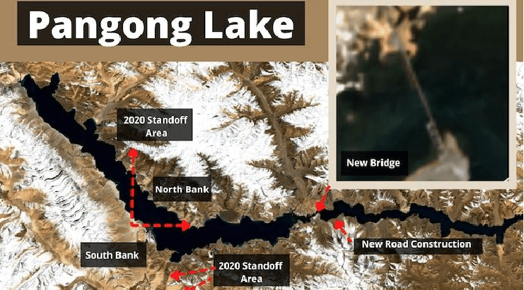
In May this year, the Indian Ministry of External Affairs (MEA) acknowledged in an official statement that China had started constructing a second bridge on the Pangong Tso Lake following the completion of the first bridge earlier.
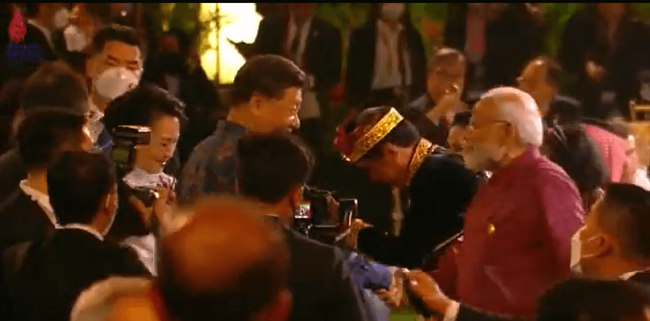
This report comes amid Chinese President Xi Jinping & Indian PM Narendra Modi’s warm handshake at G-20 Summit in Indonesia.

At the time, the Indian MEA said, “Both of these bridges are in areas that have been under the illegal occupation of China since the 1960s. We have never accepted the illegal occupation of our territory nor accepted Chinese claim or such construction activity.”
Despite stabilizing the situation at the border over time, China has continued to upgrade its border infrastructure. Speaking at the Chanakya Dialogue in New Delhi, Indian Army Chief General Manoj Pande recently flagged China’s “unabated” infra development along the LAC in East Ladakh and underlined the need for taking “very carefully calibrated” actions.
China has continued to ramp up its presence in the region. It recently conducted high-altitude patrolling drills in the Tibet military area. Besides, it has been deploying cutting-edge military equipment close to the LAC in the Eastern Ladakh sector.


General Manoj Pande signaled that the disputed Line of Actual Control situation remains “stable but unpredictable.” This is not without reason.
In the latest development, satellite imagery obtained by EurAsian Times from open source suggests that the construction of this second bridge is progressing in full earnest, despite the onset of Himalayan winter. The construction was first reported just six months ago, in May. The second bridge is reportedly bigger and broader than the first.

The visuals accessed and analyzed by the in-house analyst of EurAsian Times were compiled and converted into a time-lapse covering a period between October 6 to 31. In the time-lapse video, the bridge appears to be progressing in length despite the onset of winter and sporadic bouts of snowfall in the region at the time.

Indian Army Veteran Maj. Gen. Raj Mehta (retired) told EurAsian Times, “There is snow visible, but the cover is sporadic. Water freezes later, around December/January. I don’t think snow should be too much trouble as it is the onset of winter; term it early winter if you will.
The worrisome thing for soldiers and fuel is the wind chill factor which cuts through clothing and tents like a knife. Fuel and water freeze, the soil gets harder due to frost, and weapons malfunction.”
These two bridges have been envisioned to run parallel to each other, connecting the north and south banks of the Pangong Tso lake – a major site of a standoff between the two militaries in 2020.
In September this year, the two sides disengaged from one of Ladakh’s most hotly contested flashpoints. The two sides withdrew from Patrolling Point 15 Gogra-Hot Springs region in what was seen as the first break of the impasse in several months.
Later, in October, the two sides pledged to hold more talks and agreed to hold the 17th round of talks between senior military commanders “at an early date.” The date has not been specified. The construction activity sped up tremendously, and the bridge may be completed before the commander-level talks.
Srikanth Kondapalli, a professor in Chinese Studies at the Center for East Asian Studies, Jawaharlal Nehru University, New Delhi, said, “Yes, the 2nd bridge is about to be completed.
This is part of the larger project of a new highway connecting Karakoram pass to Nyingqi prefecture (opposite Arunachal) via Aksai Chin, Middle sector, Nepal, Sikkim, and Bhutan borders. Pangong Tso bridges have no strategic value but tactical to reinforce troops in case of contingencies.”
Long Route To India & China ‘Bridging’ The Gap
According to OSINT experts who examined the high-resolution satellite photos of the location in May this year, the first bridge is being used to transport tools like cranes needed to construct the second one.
It is pertinent to note, however, the construction of the second bridge is progressing through a deadly winter in the Himalayan region, which only gets harsh with each passing day.
Indian Army Veteran Maj. Gen. Raj Mehta (retired) told EurAsian Times, “I see no strategic implication out of winter construction. The strategic implication lies in reducing PLA reaction time which is very serious and demands exceptional alertness from us 24*7.”
It has long been noted that the distance between Chinese troop positions on the north bank of Pangong Tso and a significant PLA facility at Rutong, on the eastern end of the lake, will be reduced by about 150 kilometers, thanks to both these bridges.

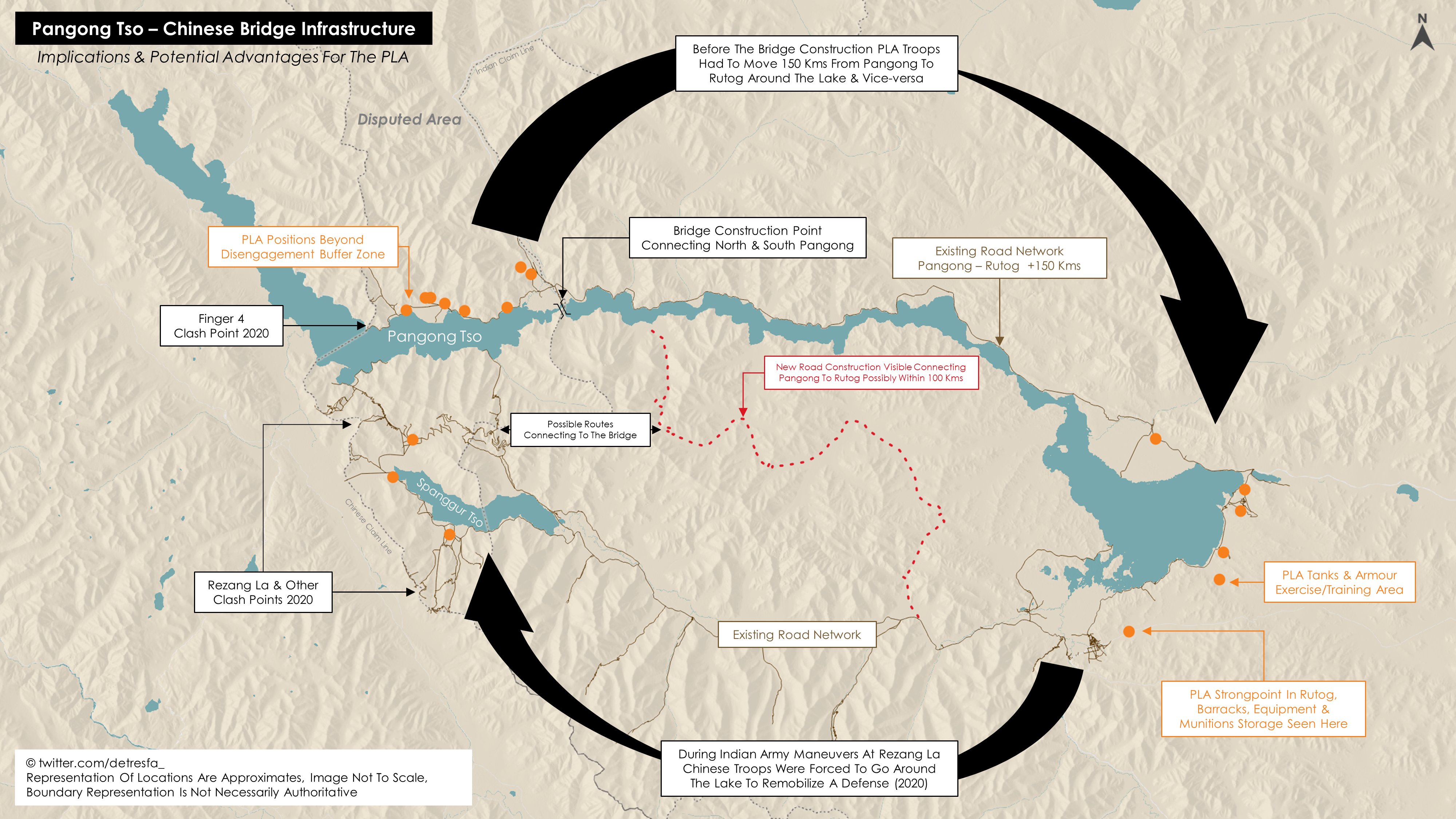
The bridges are close to Khurnak Fort, which China refers to as Rutong County. Khurnak Fort is located west of the Indian claim line. There is a frontier defense company in Khurnak Fort. The bridges are located near the LAC at one of the lake’s narrowest spots. The induction of PLA from China’s G219 Highway will be much faster.
The second bridge will most critically make it easier for mechanized and motorized formations to be introduced quickly. A metal road from the Chinese side up to Finger 4 is already there on the north bank of the Pangong Tso.
While China does not have an urgent goal to achieve, it has continued construction of infra along the LAC to attain a position of advantage. As Professor Kondapalli said, “With the corps commander meetings slow in de-escalation and disengagement, it’s an indication that China wants first to dominate the borders and then conclude any agreement with India on its terms.”
The construction is progressing even as the two sides negotiate disengagement and seek to resolve the long-standing dispute in its third winter. In the next round of talks, which could be expected before the end of this year, the two sides are expected to discuss the strategic Depsang plains.
While India maintains that there are friction points at Demchok and Depsang, China does not acknowledge that these issues predate the 2020 conflict. Demchok is one of the two mutually agreed disputed areas in Eastern Ladakh, while Depsang is one of the eight friction points that merit an immediate disengagement, according to the Indian side.

Over the last few months, China has been pushing a new normal where the border dispute and the overall bilateral relationship with India are perceived as separate issues. However, the Indian side has rejected all these attempts.
Beijing is practicing the dual policy of beefing up its military presence and sitting at the negotiating table to resolve impending issues. Completing this bridge will potentially give it more leverage at the negotiating table.
That said, it could still be a while before the PLA completes the bridge’s construction. With the new construction, China’s People’s Liberation Army (PLA) hopes to have multiple approaches to fend against any Indian Army operations on the southern banks of the Pangong Tso.
- Contact the author at sakshi.tiwari9555 (at) gmail.com
- Follow EurAsian Times on Google News


