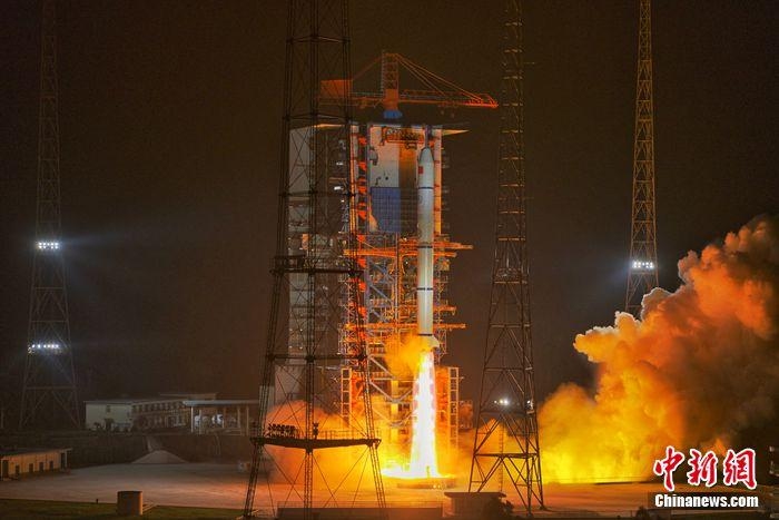
China on October 26 launched three new military satellites, termed as the Yaogan-30 series, to add to its military surveillance constellation — the Chuangxin-5. The Yaogan series is a network of electro-optical, imagery intelligence (IMINT), synthetic aperture radar (SAR), and electronic intelligence satellites (ELINT).
F-35 Fighter Jet Program – A Whooping 398 Billion Initiative Faces Full-Rate Production Delay
According to the Chinese media, the satellites will be used for electromagnetic environment detection and related tests. However, the security analysts believe the “Yaogan” name is a cover for Chinese surveillance satellites, with optical and radar payloads intended to boost the Chinese anti-access and area-denial capabilities by augmenting the Anti-Ship Ballistic Missile system (ASBM).
The Yaogan satellite constellation is designed to survey China’s neighborhood and facilitate space-based Synthetic Aperture Radar (SAR) observations, electro-optical observations, and naval oceanic surveillance for optical surveillance to track warships by acquiring their optical signatures and radio transmissions.
Currently, the country is involved in dangerous conflicts with a number of nations, including Taiwan and India, and more importantly, with the US in the South China Sea. The country has been in the need of constant surveillance from space to track enemy ships on the vast oceanic surface, which is difficult to achieve from the land.
To enable its Anti-Ship Ballistic (ASBM), China needs to effectively identify, locate, and track an Aircraft Carrier Group (ACG) in the western Pacific Ocean, before it reaches the country’s shores. This function is what Yaogan satellites are designed to perform, and the satellites provide the vital C4ISR inputs critical for a successful missile strike on a moving Aircraft Carrier Group.
These satellites fly in a triangular formation, forming what is called a Naval Ocean Surveillance System (NOSS), which enables them to scan a large area. They can pinpoint the location of any naval vessel in the ocean by tracking their electronic signals, which are continuously emitted by naval ships operating in the ocean.
The People’s Liberation Army (PLA) can form a network of the SAR, ELINT, and electro-optic satellites in orbit, enabling the integrated system to sweep any vast target area once in less than 40 minutes, enabling rapid target identification with precision, Chinese security experts claim.
If the war over Taiwan ever breaks out, China’s first effort will be to dissuade the US carrier battle groups from interdiction in support of Taiwan and force them to stay out of the area of operation. The country’s incremental progress in space-based surveillance will be its edge in discouraging any US-led offensive from the South China Sea. The Chinese experts regard the Yaogan network as being the backbone for the Chinese anti-ship ballistic missiles or the “carrier killers”.
China started launching the Yaogon series of satellites back in 2006, from Taiyuan Satellite Launch Center. Thereafter, the more advanced versions, the Yaogan-6, was launched on 22 April, 2009, and at least three follow-on variants have been launched till 2015. The new Yaogan-30 series is dubbed as the most recent electronic reconnaissance system. As of October 2019, China had 15 Yaogan-30 military satellites in orbit.
The current set of satellites provides the country’s army with a near-continuous global coverage of all US naval activities, according to reports. This ability in the Indo-Pacific region in all weather conditions is likely to enhance China’s ability to conduct military operations farther from shore.
China has over the years invested heavily in space-related research and development (R&D) to drive military capabilities and fill gaps in intelligence, reconnaissance, and surveillance. The country’s government recognizes the need for space-based infrastructure to enable the People’s Liberation Army (PLA) undertake out-of-area operations.
According to the US’s Department of Defence report, China is rapidly expanding its ISR (Intelligence, Surveillance, and Reconnaissance), navigation, and communication satellite constellations and making substantial strides in its space lift capabilities, human spaceflight, and lunar exploration programs.
China is looking to expand its space launch vehicle industry to support commercial launches and make rapid satellite launch services available to foreign customers. China is planning to launch, assemble in-orbit, and operate a crewed Chinese space station before 2025.
And with India bolstering its space-based ISR by signing the BECA with the US, under which the latter would share its military Geographic Information System (GIS) comprising topography, terrain, and weather information for mission planning.
The country, also locked in a stand-off with China, will also receive US satellite imagery (data and video), GPS military resolutions, and datasets from its airborne assets. The high-level agreement secures the future of India for the time being, as far as space-based surveillance and missile guidance is concerned.


