In 2014, India was caught off guard as a Chinese Song-class diesel-electric attack submarine surfaced in the Indian Ocean Region (IOR) and docked in Sri Lanka. The frequent forays of Chinese hydrographic vessels in the region indicated an increased presence of Chinese submarines in the Indian neighborhood.
In anticipation, India is building its military capability in the Andaman and Nicobar Islands that sit on the mouth of Malacca Strait, where the Chinese submarines have to surface to enter the IOR.
The latest satellite photos indicate significant capability augmentation at the strategically located Car Nicobar air base. India is increasing its operational capacity by increasing the length and width of the runway.
The longer taxi track can serve as a secondary runway, “facilitating smoother and more efficient operations.”
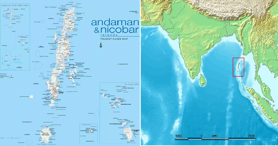
Located at the confluence of the Indian and Pacific Oceans, the Andaman and Nicobar Islands are said to be one of the world’s most strategically located island chains.
The Indian government is developing the islands’ military assets as part of a 10-year infrastructure development. So far, Indian Air Force (IAF) fighter jets Jaguar Maritime Strike Aircraft and Sukhoi Su-30MKI are deployed at Carnicobar for some duration.
Capability enhancement would pave the way for a fighter squadron to be stationed on the island permanently. The IAF C-130J Super Hercules transport aircraft can also operate from the island following the capability enhancement.

Car Nicobar is located in the Andaman and Nicobar Islands, in the Bay of Bengal, at roughly 9 degrees north of the equator. The Island is 15 km long and 12 km wide, with a 51 km coastline.
Car Nicobar is 270 km south of Port Blair. Normally, a ship is available twice a week to Port Blair. Indian Air Force (IAF) operates charter services between Port Blair’s Veer Savarkar International Airport, Campbell Bay, and Car Nicobar Air Force Base.
The 914-metre (3,000 ft) bitumen runway on the island was built by the Japanese during their occupation of these islands between 1942 and 1945.
After 1945, it was used by the British Royal Air Force as a refueling base for regular flights between RAF Negombo (now Colombo International Airport) in Sri Lanka (then Ceylon) and RAF Changi in Singapore and vice versa. The runway was extended to 2,717 meters (8,914 ft) by the IAF in 1967.
Before the Tsunami wreaked havoc on the islands, Carnicobar was serviced by Russian An-32, Port Blair had a runway used by civil airlines, and the southernmost point, Campbell Bay, was serviced by helicopters. Now, India has four runways in the archipelago, making it possible for the Indian forces to operate independently from all regions of the island chain.
The island runways are being extended to let the Indian Navy’s P-8I operate from there to boost its anti-submarine capabilities in the region. India is the second biggest P-8I maritime patrol aircraft operator after the US military.
INS Baaz naval station was inaugurated on July 31, 2012. It is a full-fledged “forward operating base” of the Indian Navy. It overlooks the six-degree Channel, one of the most crucial shipping lanes in the world, a vital choke point. It will soon become India’s eye over the Malacca Strait and the Bay of Bengal. There is a 1,050m (3,445 ft) asphalt runway. There are plans to extend the runway to 10,000 feet in the future.
The INS Utkrosh in Port Blair has a runway big enough for the P-8Is to operate. That station is currently home to a squadron of short-range Dornier-228 maritime patrol aircraft.
In 2019, India established the Kohassa Naval Air station on the northern end of the Andaman Islands, near a suspected Chinese intelligence outpost on Myanmar’s Coco Island. Plans are afoot to extend the runway as well to accommodate P-8Is.
Apart from relocating warships and anti-ship missile batteries on the islands, the Indian Army has been test-firing its BrahMos anti-ship missiles from the islands, the latest one being done on January 15, 2025.
The northernmost point of the 572 islands is only 22 nautical miles away from Myanmar, and its southernmost point is a mere 90 nautical miles from Indonesia. The islands control the Bay of Bengal, the Six Degree, and the Ten Degree channels, which over 60,000 commercial vessels use.
India’s Defense Minister Rajnath Singh said on January 15 that international power rivalry is playing out in the IOR and that a strong naval presence in the key trade route was the country’s biggest priority.
“A large part of the world’s trade and commerce passes through the Indian Ocean region. Due to geo-strategic reasons, the region is also becoming a part of international power rivalry,” Defense Minister Singh said during the induction of one submarine and two navy ships in the city of Mumbai.

Chokehold On Chinese Trade Route
The 572-item Island chain is emerging as an essential part of India’s strategy to balance China’s burgeoning dominance in the Indo-Pacific.
Over the past decade, the presence of the Chinese Navy’s surface ships and submarines in the Indian Ocean has become ubiquitous. In 1962, when India and China fought their first war, a Chinese submarine was sighted in the IOR, after which the Indian government sanctioned a 150-sailor garrison on the islands.
The biggest advantage of the island chain, which is located over 1200 kilometers away from mainland India, is that it controls important choke points like the Malacca Strait, one of the busiest shipping lanes in the world. Hence, India is on a quest to strengthen its position in the archipelago and maintain a stable Indo-Pacific.
The Malacca Straits connects the South China Sea and the IOR. The Islands will be converted into a shipping hub and tourist destination under a US $9 billion project.
The project scale can be gauged by the promotional video released by the Ministry of Ports, Shipping, and Waterways. In March 2021, NITI Aayog unveiled a Rs 72,000 crore plan called ‘Holistic Development of Great Nicobar Island at Andaman and Nicobar Islands.’
It includes the construction of an international transshipment terminal, an international airport, a power plant, and a township. The project will be implemented by the Andaman and Nicobar Islands Integrated Development Corporation (ANIIDCO), a government undertaking.
Talking about the strategic importance of the isles, former Indian Navy chief Admiral Arun Prakash wrote that the military assets stationed here need to be beefed up as “the frequent transits of PLA Navy (PLAN) warships, submarines, and research/intelligence-gathering vessels in these waters portend a sustained Chinese naval presence, including nuclear attack submarines.”
“This would require the IN (Indian Navy) to maintain a substantial anti-submarine warfare capability in the A&N,” the former Indian Navy chief contended.


