A remote sensing satellite powered by the latest Artificial Intelligence (AI) technology was able to detect and track the USS Harry S. Truman in real-time while it was headed to a strait transit drill off the coast of Long Island in New York on June 7, 2021, Chinese researchers have claimed.
US Navy Amassess Its ‘Most Advanced’ Warships In Japan To Hunt Chinese Submarines, Defend Taiwan
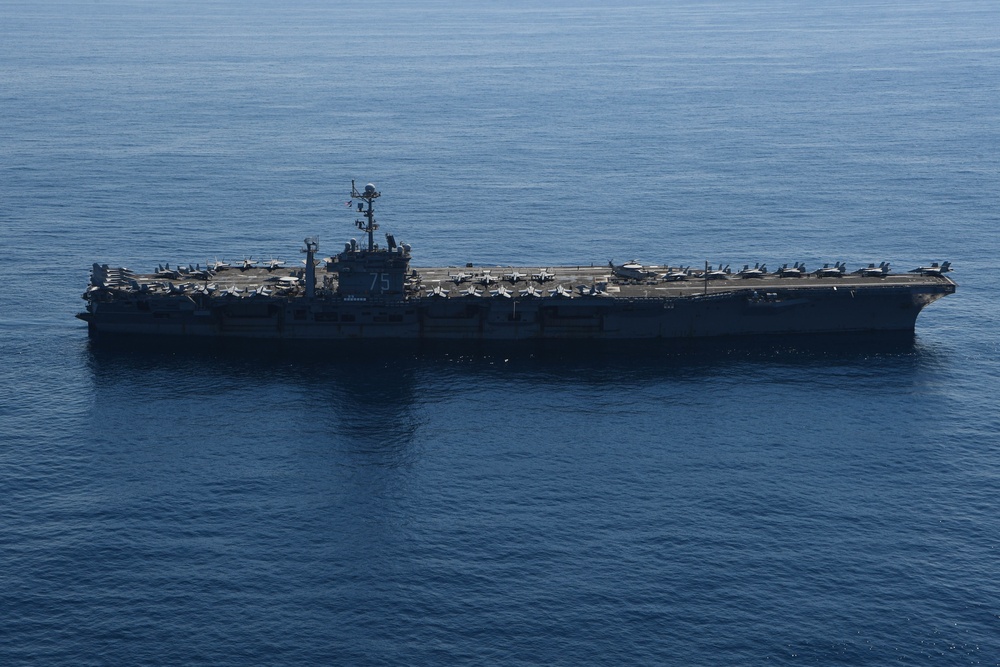
The aircraft carrier – USS Harry S. Truman, was taking part in a Surface Warfare Advanced Tactical Training (SWATT) exercise which was a live-fire drill involving the Carrier Strike Group 8 (CSG 8).
A total of seven ships consisting of six Arleigh Burke-class guided-missile destroyers and one Ticonderoga-class guided-missile cruiser, and many planes simulated a fight against a powerful enemy while passing a narrow passage of water.
According to the US Navy, numerous tactics were tested during the exercise, like changing formation and making emergency maneuvers to deter enemy submarines and other threats.
According to claims by Chinese researchers, the AI-powered satellite automatically detected the Nimitz-class aircraft carrier and alerted Beijing with precise coordinates.
New Chinese AI-Powered Satellite
The claims were made by a team of researchers from DFH Satellite, headed by Yang Fang, in a paper published in the domestic peer-reviewed journal Spacecraft Engineering in April.
DFH Satellite is a Chinese Aerospace and Defense company wholly owned by China Spacesat Co., Ltd. and its activities come under the China Academy of Space Technology (CAST).
CIA Expert Decodes Why Russia Which Even Hacked Into US Power Grids Is Failing In Cyber War In Ukraine
In the past, the Chinese military had to collect and analyze a huge amount of raw satellite data on the ground to get a clue on the details of such drills taking place in the US home waters, and the results usually came after the event was over.
But with AI-powered satellites, Beijing could detect and “live stream” military activities or assets of interest on the other side of the planet.
The Chinese team claimed that the satellite which caught the Nimitz-class aircraft carrier in action was so smart that it could identify a wide range of tactical or strategic targets by analyzing more than 200 frames of high-definition images per second, a speed that some ground-based computers would struggle to achieve.
Putting AI into space involved many challenges, according to a Beijing-based satellite imaging researcher who was informed about the study but requested anonymity due to the sensitivity of the technology.

The mainstream AI algorithms required extensive training based on a huge amount of data, but the calculation resources in the orbit were rather limited, the researcher said.
Satellite computers usually lag behind their ground-based systems in terms of processing speed due to their weight, space, and power constraints, and they have to work for years in a harsh environment without a glitch. According to the researcher, most chips designed to handle AI tasks would fail quickly under strong radiation.
Eying A $1 Trillion Industry, ‘Resource-Hungry’ China Rapidly Increasing Tech For Asteroid Hunting
Yang’s team claims to have achieved a breakthrough in “weight reduction” for AI technology. According to their paper, the image recognition with the algorithm they developed for the satellite consumed just three percent of the calculation resources used by traditional algorithms when doing the same task.
They also produced a new family of AI chipsets that could perform many different types of tasks simultaneously onboard the satellite. If one chip failed, another would serve as backup and immediately take over the job to ensure the continuous functioning of the satellite.
Yang’s team said that there were some clouds over the New York region during the USS Harry S. Truman strike group exercise, but their satellite was able to identify the aircraft carrier in the gaps of clouds with a sharp image containing so much detail that it almost ruled out the possibility of a mistake.

Also, the team conducted another test to verify the performance of space-based AI, wherein the same satellite automatically detected and obtained the coordinates of military aircraft, naval ships, and strategic assets such as oil storage tanks in northeastern Australia.
The researchers did not name the satellite reported in their paper.
Yang and her colleagues said the smart satellite could increase communication efficiency by a million times because the AI would remove most of the junk information that jams the channels.
US May Surpass China In AI
President Xi has prioritized AI in his quest to make China a dominant power and even issued a mandate to become fully modernized by 2035 and on par with the US military by 2050.
Accordingly, the Chinese military is making efforts to research, develop, and operationalize AI for military purposes. However, China’s leaders fear that the US may surpass and develop systems that can overwhelm its air defenses and assault its command and control systems.
In October of last year, the US Army undertook AI-enabled live-fire target identification exercise, as part of its Scarlet Dragon series of exercises.
:quality(70)/cloudfront-us-east-1.images.arcpublishing.com/mco/DVJVP6KAORELHNGNPFKBJN57FU.jpg)
As part of the exercise, the US Army’s XVIII Airborne Corp scanned 7,200 square kilometers of area across four states on the eastern seaboard from Virginia to Georgia and used AI to find and destroy specific simulated targets in an area the size of a 10-square-foot box.
The satellite imagery was provided by the National Geospatial-Intelligence Center, and the software used to analyze the imagery and identify targets came out of the Pentagon’s Project Maven, the military’s flagship AI-for-targeting effort that had started in 2017.
Initially, Maven looked at full-motion video feeds from drones to quickly process them for target ID and selection, but the US Army used the same technology for satellite images.
“We have been able to reduce the speed of moving data from sensor to shooter by nearly 50 percent,” said Col. Melissa Solsbury, the chief data officer for the Corps at the time.
- Written by Tanmay Kadam/EurAsian Times Desk
- Contact the author at etdesk@eurasiantimes.com
- Follow EurAsian Times on Google News


