The US does not have an operational hypersonic missile or a working defense against it, while its rivals wield advanced hypersonic weapons. After registering success in testing hypersonic weapons, it is now pursuing a space-based system to combat the threat from adversarial missiles that are hard to track.
HIMARS ‘Wreak Havoc’ On Russia! Ukraine Bombs Key Supply Bridge Using US Multiple Launch Rockets (MLRS)
To that end, two new contracts for a constellation of missile surveillance satellites were announced by the US Space Development Agency (SDA). The satellites will track and monitor ‘Chinese and Russian’ hypersonic missiles.
The contracts were awarded to L3Harris and Northrop Grumman on July 18 for a total cost of $1.3 billion. The advanced satellite system, a capability that neither China nor Russia has, will be launched into space by 2025.
According to a press release from SDA, each company will construct 14 satellites as part of the Other Transaction Authorities (OTA) contract. L3 Harris received one award, with a possible value of nearly $700 million, and Northrop Grumman received another, with a potential value of about $617 million.
This development comes even as the US Missile Defense Agency (MDA) is working diligently on a Glide Phase Interceptor (GPI) to intercept the hypersonic missile and shoot it down in the middle of the flight’s most vulnerable phase.
In June, MDA selected Northrop Grumman and Raytheon Missiles and Defense to continue developing prototypes for GPI.
The MDA plans to develop a multi-layered defense system that integrates radar on the ground, satellite-based sensors, and other military weapon systems into a single network to locate, track, and potentially intercept and destroy hypersonic targets.
In February 2022, SDA announced awarding three prototype contracts totaling about $1.8 billion to a mesh network of 126 optically interconnected space vehicles (SV). The objective was to deliver a reliable, low-latency, high-volume data transport communication system and be prepared for launch beginning in September 2024.
US Worried That China Could Declare No-Fly Zone Over Taiwan; Shoot-Down ‘Invading’ Aircraft Amid Pelosi’s Visit
Building on this concept, 28 small satellites will be launched by SDA into low Earth orbit. The satellites are intended to deliver the initial missile warning/missile tracking capabilities of the future National Defense Space Architecture or NDSA.
Why A Satellite-Based System
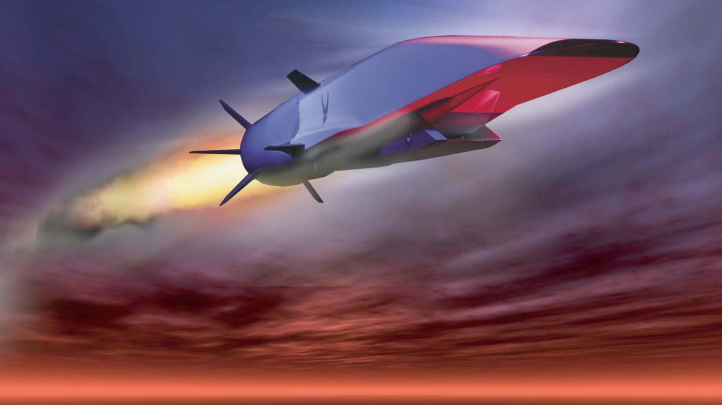
Hypersonic missiles can travel up to 6,200 km/h (or more than five times the speed of sound) in the upper atmosphere and could fly 100 feet above the ocean without being seen.
There are currently three categories of such weapons: aero-ballistic, glide vehicles, and cruise missiles, according to Aerospace Engineer Iain Boyd in a piece that appeared in The Conversation.
Due to their distinctive flight characteristics, boost-glide vehicles are significantly more challenging to track than other weapons like ballistic missiles. These vehicles are launched into the atmosphere after being propelled by a rocket to the required speed and altitude.
Derek Tournear, director of the Space Development Agency, said the US had not flown satellites designed to detect and go after such maneuverable hypersonic weapons. He said, “we have limited capability to do that tracking aspect,” adding that “clearly we don’t have zero capability to do tracking.”
The Space-Based Infrared System (SBIRS) constellation, which has a relatively small number of bigger satellites, provides the US military with its existing capabilities for space-based early warning. However, it only works for conventional ballistic missiles, not hypersonic weapons.
US adversaries Russia and China wield sophisticated hypersonic weapons. While China conducted a test in which its weapon went all around the globe, Russia has used hypersonic weapons against Ukraine in the ongoing conflict. The need for interception, tracking, monitoring, and killing these missiles is, thus, urgent.
How Will The Satellite Network Work
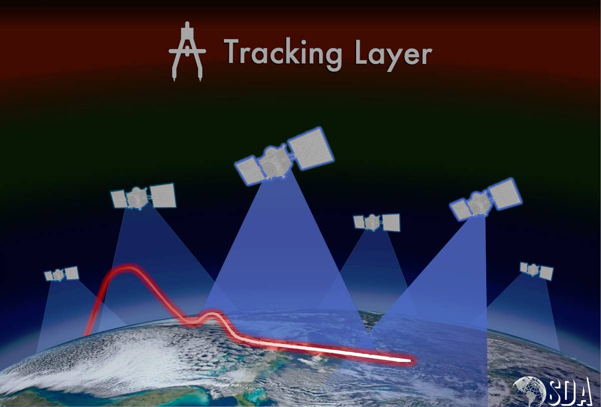
National Defense Space Architecture is made up of two tiers of space-based platforms known as the Transport Layer and the Tracking Layer. Two sets of satellites will be present: one in a medium orbit of roughly 10,000–20,000 kilometers, offering a more robust presence, and the other at a lower orbit of about 1,000 kilometers.
Essentially a communication layer or constellation, the Transport Layer will offer assured, resilient, low-latency military data and connection to the complete range of warfighter platforms worldwide. It is intended to be a constellation of between 300 and 500 satellites in low Earth orbit (LEO) at an altitude between 750 and 1,200 kilometers.
With an entire constellation, at least two satellites will be visible in 95% of Earth’s locations at all times, and at least one satellite will be visible at 99% of Earth’s locations.
The Tracking Layer will provide indicators of advanced missile threats worldwide, including hypersonic missile systems and warning, tracking, and targeting information. This capacity includes algorithms, cutting-edge processing techniques, data fusion across sensors and orbital regimes, and tactical data products that may be sent to the right user. It also includes space-based sensing.
Each satellite will be positioned in a polar orbit, enabling them to circle the Earth from north to south. However, they will be spread over four separate planes, or regions, worldwide. It will therefore require four launches to deliver them, according to Tournear.
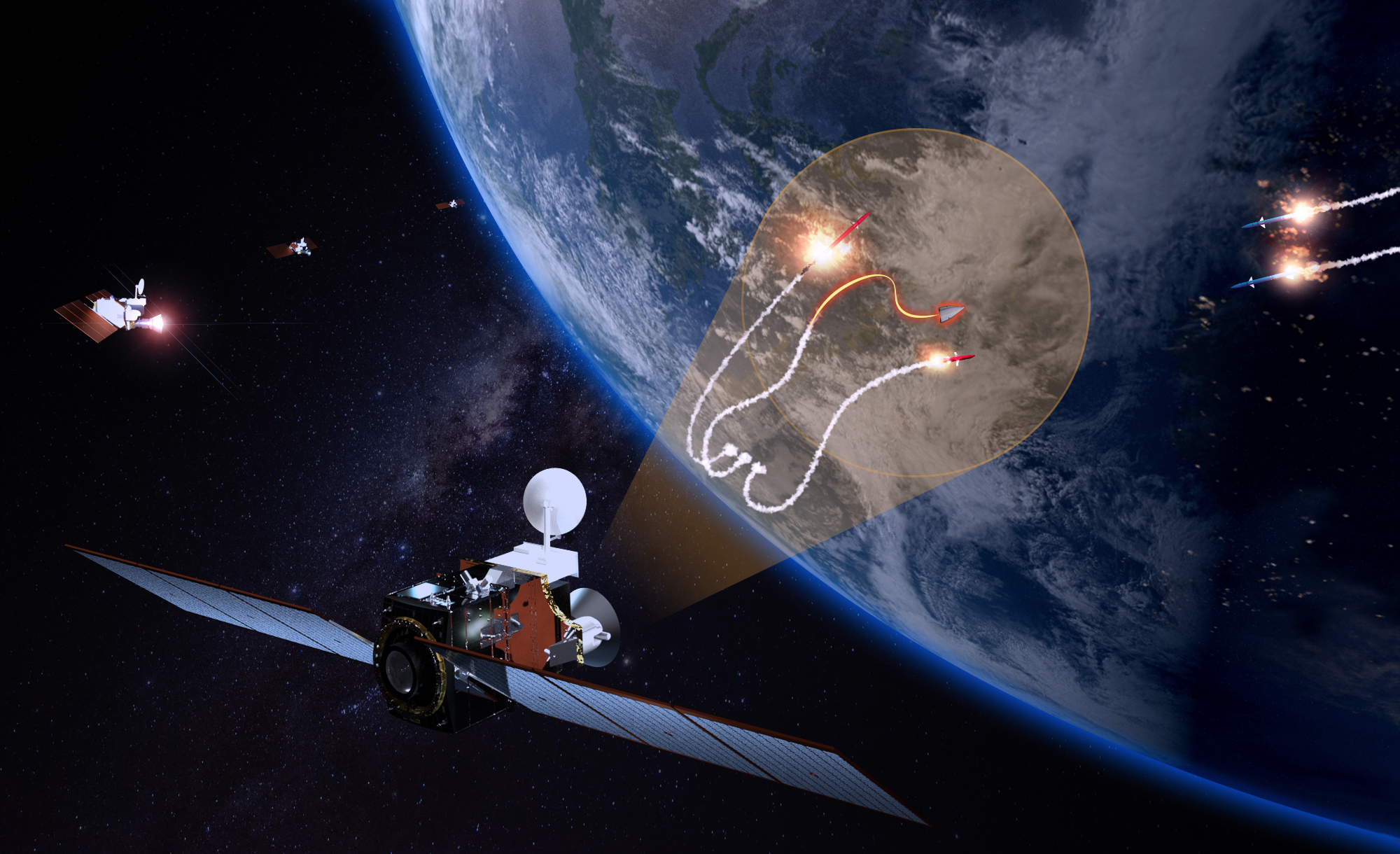
After separating from the booster rocket, the hypersonic glide vehicle starts to move as it heats up in the atmosphere. When that occurs, the US tracking satellites can spot it instantly. The monitoring satellites will start calculating and updating a two-dimensional trace of the missile’s course.
The transport layer satellites will then transmit the information to a ground station, fusing all of those two-dimensional tracks – from multiple tracking satellites – together in hundreds of milliseconds.
“And that means that now I can form a three-dimensional track,” which “is important because that could be used to send an interceptor to take out that hypersonic maneuvering vehicle,” said Tournear.
But in addition to that interceptor, troops on the ground also require knowledge about the potential landing location for the hypersonic weapon. Despite having direct connectivity to the transport layer data sources, they don’t have direct connectivity to all these tracking layer satellite data feeds.
“Once those data get to the transport layer, whether that’s a two-dimensional track or a three-dimensional track, once several of these tracks from different satellites are merged, I can send those data directly down via Link 16, which is an existing tactical data link that exists on a lot of our DoD platforms. It also exists on handheld types of radios.”
So that troops can decide based on that information whether to take cover or whether to engage other radar or weapon systems to intercept the hypersonic maneuvering vehicle, the information can be delivered down directly to the theatre.
EurAsian Times reached out to Defense and Space Analyst Girish Linganna to better understand how the network would work. He says, “The key concept is to deploy a constellation with specialized sensors. These sensors detect infrared radiation, and the data is analyzed in real-time to check if this could potentially be the missile launch stage. Upon this determination, the constellation communicates with each other to check where the object is traveling and map the trajectory.”
“The proposed system would use two layers of constellations: one in Low Earth Orbit and one in Medium Earth Orbit. This layered system will also be beneficial in detecting hypersonic glide vehicles such as Chinese DF-ZF.
The aim here is to be equipped for the future to detect the highly maneuverable hypersonic missiles that might be able to blaze through traditional naval defenses. This system will increase global awareness with a growing focus on the Indo-Pacific region“, he added.
A Dispersed, Short-Duration Network
Using this vast, dispersed network of little satellites, the Tracking Layer would be more responsive, adaptable, and resilient to the increasingly likely threat of an enemy anti-satellite attack.
It will be a continuation of the eight-satellite Tranche 0 Tracking Layer, which will launch two in September and another six in March of the following year.
In 2020, the United States military contracted L3Harris and SpaceX to develop small satellites with potent infrared sensors that can detect and track ballistic missiles and hypersonic weapons.
These satellites were envisioned as a precursor to a more extensive and comprehensive early warning constellation consisting of hundreds of space-based sensors and communications nodes.
According to Tournear, the program signifies a shift toward a more extensive, overlapping system of satellites. The US will have a more significant number of less expensive satellites that would be replaced roughly every five years rather than depending on larger, more costly satellites that remain in orbit for 15 years or longer.
While the system is far from operational now, it does sound aspiration, especially given that no other country yet has a defense against hypersonic missiles. China had earlier claimed that it had developed a technology to intercept hypersonic missiles, but the information’s authenticity has not been officially confirmed.
When operational, this satellite network would be a key breakthrough for the US, which has lagged in the hypersonic race.
- Contact the author at sakshi.tiwari9555@gmail.com
- Follow EurAsian Times on Google News


