
The Chinese inroads into space have got strategic circles abuzz with discussions about a possible revival of a Cold War-type competition between the US and the erstwhile Soviet Union.
China has yet again made headlines with a move that goes beyond just sending missions to the Moon or Mars. It has claimed to have launched a satellite that could take high-resolution photos of American cities from space, which can capture even details of a vehicle’s number plate.
According to experts, a Chinese satellite captured photographs of a vast region around a US city in just 42 seconds, crisp enough to recognize a military vehicle on the street and tell what type of weapon it might be carrying.
🇨🇳#China's Beijing-3 satellite rotates 10°/sec, taking images at 50 cm/pixel while wildly rolling & yawing, allowing better overall performance than US competitors though not as sharp {30 cm/pixel}
Response time is 2-3 times faster than WorldView-4, US' most advanced observation pic.twitter.com/iHOC0MU8Vr
— Devi Rhamesz (@ChrliesWarchest) December 27, 2021
Beijing-3, a small one-ton commercial satellite launched by China in June, completed an in-depth survey of the core area of the San Francisco Bay (3,800 square kilometers), stated scientists involved in the project.
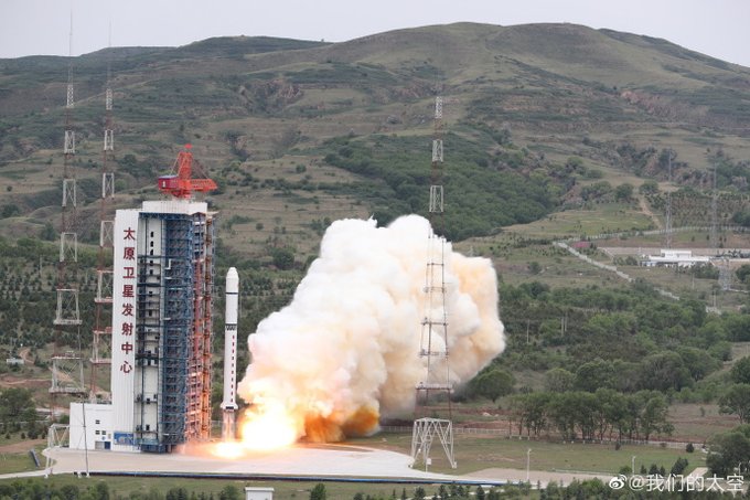
China has launched a number of earth-observation satellites for various purposes. Previously, on December 26, China launched a new satellite with a camera that can snap five-meter-resolution photographs of the ground, according to the China National Space Administration (CNSA), reported by The Times of India.
The satellite, known as “Ziyuan-1 02E” or “five-meter optical satellite 02,” was launched from the Taiyuan Satellite Launch Centre in Shanxi Province, China, by a Long March-4C rocket.
In an article published this month in the domestic peer-reviewed journal Spacecraft Engineering, project lead of Beijing-3, Yang Fang and her colleagues wrote, “China started relatively late on agile satellite technology, but accomplished a high number of advances in a short amount of time.” “Our technology has advanced to a world-leading position.”
How Does This Satellite Maneuver?
Taking high-resolution pictures from space is a very challenging task as attitude control devices can induce vibrations that blur photographs. Due to this technical constraint, most Earth observation satellites must be steady when capturing images.
According to Yang, Beijing-3 is the most nimble satellite and could be one of the most powerful Earth observation satellites ever created, despite its tiny size and low cost.

Beijing-3’s unrivaled nimbleness allows it to complete some observation tasks previously thought to be technically impossible, such as taking images of the 6,300-kilometer-long Yangtze River between the Tibetan plateau and the East China Sea in just one fly-by from north to south over China, stated Yang and colleagues.
The satellite could design its flight itinerary independently, monitoring up to 500 regions of interest across the world with roughly 100 revisits every day, according to artificial intelligence equipment on board. This makes this nimble satellite highly intelligent and able as compared to what China has fielded in the past.
Even as the satellite was rotating and tilting at record speeds, the Chinese team claimed they had utilized a novel technology to reduce vibration.
The Beijing-3 satellite was developed on the CAST3000E platform, which would pave the way for a new generation of Chinese observation satellites that were tiny in size but powerful.
Solar panels on the new platform had a special construction to keep them from swaying as the satellite spun swiftly and sharply. Any components that are suddenly exposed to the light could be overheated to counter which an advanced cooling system is used.
To safeguard the satellite from the physical toll caused by rapid movement, critical components such as telescopes and antennas were developed employing innovative technologies such as AI control.
The satellite may also detect the existence of specific targets and provide ground control photographs of them and the response time of Beijing-3 is 2-3 times faster than that of WorldView-4, considered the most advanced earth observation satellite to date, created by the United States with similar technology.

This could send the alarm bells ringing in Washington that remains locked in a modern-day cold war with China. Earlier this year, just over a month after this satellite captured photos of a region in the United States, a hypersonic test mission was carried out by China that had shocked and the West.
However, despite the Chinese constant upgrades and innovation, the Earth-observation market is still dominated by the West. The Chinese satellite Beijing-3 could be a response to the American WorldView-4, which is said to have retired in 2019 due to technical issues.
China’s Growing Space Ambition
Beijing-3 is not the first satellite that could be a cause of concern to its arch-foe, the United States. In November this year, China launched its third Gaofen-11 reconnaissance satellite bringing the total number of classified satellites with an optical resolution that claim to rival top US spy satellites to three.
[🔴China’s 44th launch in 2021] At UTC 01:51 Nov 20, Gaofen(高分/HighRes)-11-03 satellite was successfully launched by CZ4B rocket at Taiyuan Launch Center, Shanxi. It’s also 397th flight of Long March rocket family. HD Video: https://t.co/sG582LxwrR pic.twitter.com/nl5JJt3Ma4
— CNSA Watcher (@CNSAWatcher) November 20, 2021
Earlier, it had launched the Gaofen-7 imaging satellite in November 2019 which can take high-resolution, three-dimensional images. The satellite is sensitive enough to height to detect a single individual from a distance of 500 kilometers.
In September this year, China launched the Gaofen 5 (02) hyperspectral Earth observation satellite which could monitor hundreds of narrow light channels, ranging from ultraviolet to long-wave infrared allowing it to provide photographs that show the chemical-physical makeup of objects in the image.


The Chinese government approved the implementation of CHEOS in 2010 in order to increase the overall capabilities of China’s Earth observation system. The Fengyun, Haiyang, and Ziyuan satellite series, as well as a constellation, were created by China (composited by small satellites).
The CHEOS program combines the elements of a space-borne system, a near-space system, an aerial system, a terrestrial system, and an application system to achieve high temporal, spatial, and spectral resolution Earth observation. The constellation could be used in Chinese President Xi Jinping’s regional development project, Belt and Road Initiative (BRI).
China’s space program has been watched keenly by the United States as a race continues between the two rivals. While many Chinese Earth-observation satellites serve civilian purposes, there are others for reconnaissance and surveillance purposes. Beijing-3 could prompt the US to develop a similar satellite if the claims made by Chinese scientists are confirmed.
- Contact the author at sakshi.tiwari9555@gmail.com
- Follow EurAsian Times on Google News


